Five years in the planning and five days in the execution. Together with my good mate Hamish, we recently undertook a five day mountain bike ride dominated by sweet purposely built single track set amongst a backdrop of jaw dropping scenery in the backcountry of the beautiful Kahurangi National Park (top North Western quarter of the South Island, New Zealand). Coupled with a magical dry spell in an area that is usually associated with heavy rain, I couldn’t help myself but compile some words to wrap the whole project up.
The journey as such was first conceptualised five or so years ago after the Heaphy finally opened up to mountain biking after decades of absence. Then came the completion of the Ghost Road linking the Buller Gorge and the West Coast and we naturally started to talk about the ‘circuit’. There was the problem of the rather significant gap linking the Northern end of the Heaphy with the southern end of the Ghost Road of course, but in the end we limited our damage (aka road riding) by adding on the reasonably unknown Flora Saddle to make it a three part trip in essence. The three pass, 530 km loop of the Kahurangi was born.
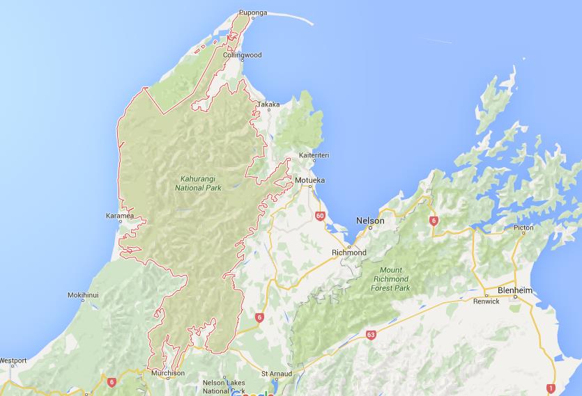
Kahurangi National Park – Our route took us from Murchison to Mokihinui to Karamea to Takaka and back to Murchison
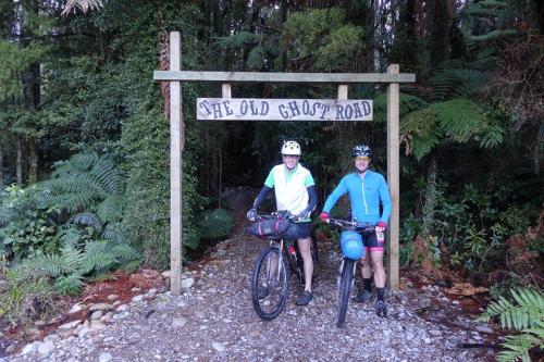
The Ghost Road.
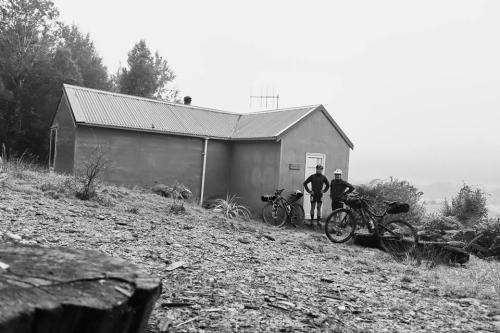
We arrived in Murchison the evening before set off. It had been raining solidly (West Coast style where the rain is measured in metres not millimetres) for the previous few days and it was still wet and rather dark when we pulled up to our motel. However, even the surprise of a queen bed to share didn’t dampen our spirits for the five days of riding ahead and the snoring competition soon commenced.
Friday morning alarm clocks stirred us into action and we were soon packed and under lights for the first 35km road section to the start of the trail proper at Lyell; the highway truckers thankfully giving us a wide berth.
As the sun slowly rose, the clouds parted and the promised dry day started to develop as we arrived at track start shortly after dawn. We quickly greeting some other mountain bikers gearing up for a day of fun and with anticipation into the bush we went.

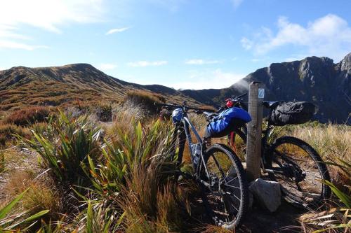
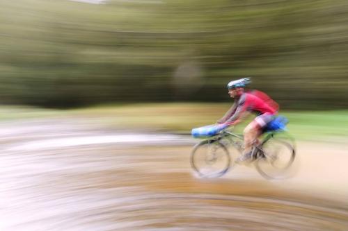
Pit Crew (Photo: Hamish Southcott)
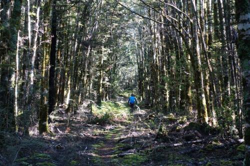
The first 18km saw us winding upwards through dripping podocarps, their lichen encrusted trunks guiding us up the well graded dray road. I could imagine the ore trolleys from bygone days, laden with rock, trundling down towards Lyell for some cyanide aided gold separation activities. I’m pretty sure the prospectors of the day could never have imagined their hard fought track would ever be used for activities as frivolous as mountain-biking, or even imagined that people would ever be frivolous. Stops were frequented by South Island Robins who like race car mechanics would arrive instantly, check the tension of our spokes, our bags for secureness and the ground for crumbs, before watching us pedal off in to the distance.
After climbing for a good three hours, the forest canopy lowered and the drooping leaves of the mountain neinei signalled that we had gained a significant amount of altitude. We soon popped out at Lyell Saddle and to some sweet views of the South branch of the Mokihinui River in the distance; we would be up and beyond our field of view by nightfall.
The bikes resting up near Bald Hill (Photo: Hamish Southcott)
Not a bad commute if you can get away with it

Travelling light has its rewards (Photo: Hamish Southcott)
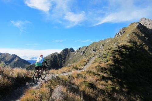
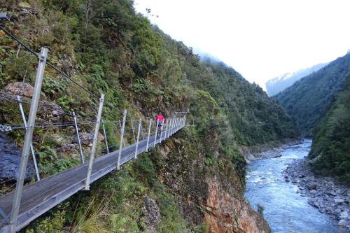
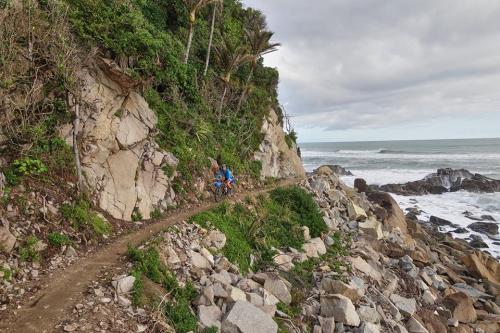
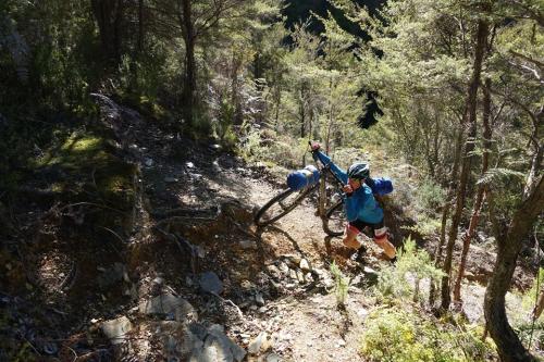
The next hour of riding saw us towering above the valleys as we traversed the Lyell Range around the aptly named Bald Hill and Rocky Tor. With our starting point – Murchison, clearly visible 30 km as the crow flies to the south east and the best part of a kilometre below us, the track cut deep into the side of the steep rocky ridge. We marvelled at the tenacity of the modern day trail builders, completing the connection between the Buller and Westland regions with the aid of an old map showing the original planned trail that was never built. A lot of time and effort had gone into making this connection as well as building ridable bridges and securing routes across landslides that had resulted from the Murchison Earthquake back in 1929. The track had amazing fluidity considering the steep and varied terrain and by the time we approached the stunningly positioned Ghost Lake Hut I realised that there had barely been a single unrideable metre the whole morning.
The Bone Yard at dusk (Photo: Hamish Southcott)
Time was ticking though and after the ubiquitous museli bar we descended the switchbacks before a precipitous portion of ridge riding. At the end we dismounted and descended the Skyline Steps back into the bush. So disappointed it was it seems – that the track builders had to revert to unrideable steps, that at the bottom was a plaque seemingly apologising for the inconvenience by outlining the efforts they had gone to to avoid such a thing. The conclusion was that steps were the only viable option.
A long curvy decent followed which spat as out at Stern Valley Hut. The hut held the heat of the day while outside the coolness of the short winter’s days was beginning to creep into the extremities. Despite having already booked a couple of beds at the hut we decided to push on; there was still remaining light, we were buzzing and we were conscious of our overall five day time limit for the whole circuit – 3 pm finishes just weren’t going to cut it, no matter how early we started.
So we headed off into the ‘Bone Yard’, a confused mass of rocks and by the looks of it the results of some earthquake (isn’t everything in New Zealand?), on the way up to Soleman Saddle. All remaining energy was squeezed to maximum capacity before a short decent in the very last light of the day to Mokihinui Forks Hut.
Mokihinui Forks Hut (Photo: Hamish Southcott)
Tired, cold and hungry we crashed into the hut and set about getting the fire going. Unlike most of the huts on the route, Mokihinui Forks Hut did not have gas so the evening’s entertainment involved trying to get the DOC issue stove hot enough to boil some water in order to aid dinner cooking. A large can of luke warm baked beans served as an appropriate entrée and kept the hunger pains at bay and after three hours, dinner was demolished in five minutes and it was time to hit the hay.
The next morning dawned fine and more spectacular riding down the true left of the Mokihinui kept smiles on our faces. We were both grateful the planned Mokihiui hydro damn hadn’t seen the light of day and another pristine New Zealand valley gobbled up under water in the process.
Happy Bikers
The Mokihinui (Photo: Hamish Southcott)
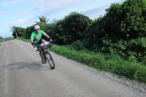
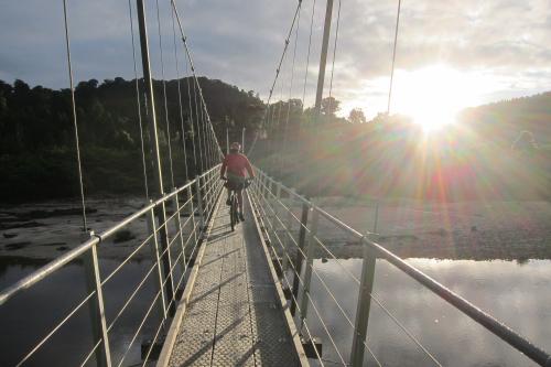
We were spat out at Seddonville – population not that many (or potentially none). With Hamish’s extensive knowledge of New Zealand’s remote pubs and cafes and the quality of their pies and chips (a true sign of over indulgent brevet riding), we gave the pub a wide berth. With the Ghost Road now finished, we soon set ourselves in pursuit mode through a mix of forest and cow country over 70 km of reasonably sedate and mindless sealed roads to the remote settlement of Karamea.
We stocked up at the local supermarket, filled ourselves with pies and weary of the ticking clock, road the last 17km of sealed road to get to the southern end of the Heaphy Track by 3pm.
Heaphy Track.
Closing in on the Heaphy
Just a small part of the amazing West Coast (Photo: Hamish Southcott)

Closing in on Heaphy Hut and the end of day 2
The Heaphy was like a different world compared to the Ghost Road. I remember when I first walked the Heaphy about 10 years ago how unusual and different the forest was to everything else I have ever encountered in New Zealand. The dense stands of Nikau Palms were more akin to riding in Fiji than the South Island of New Zealand, but we relished the change as the sun dipped low on the horizon and we battled our way up and down short pinch climbs, rocky outcrops and the odd sandy patch as the classic West Coast Ocean roared beside us. There is nothing quite like the West Coast beach on a good day… or a bad day I might hasten to add.
Mountain bikers are well looked after by DOC in these parts
My legs felt good considering I had ridden 12 hours the day before (my longest ride by practically 10 hours in over six months) and we easily picked off the track to Heaphy Hut before sunset. We dumped our gear in the busy hut – I couldn’t help but notice that of the twenty of so bikes on display out front, mine was the only hard tail (dual suspension bikes are never going to take off!), and after a quick dip in the freezing Heaphy River, watched the sunset at the water’s edge. The breakers crashed before us and slowly the sounds of Tui were replaced by the rasping of the ubiquitous hut Wekas. The night was spent talking biking, walking and adventures with our fellow hut dwellers before the tired body was allowed a few hours kip.
Somewhere near Perry Saddle (Photo: Hamish Southcott)
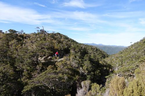
Day three dawned cloudy, but it soon cleared as Hamish and I made our way away from the coastal forest and weaved our way up a fern sagging route walled by large stands of regenerating rimus to the tree line and James MacKay Hut. We marvelled at the long view down to the coast from which we had just come from. The cold biting wind cut through us and made sure we didn’t dwell long. We were soon riding over the a mix of alpine scrub, bogs, short valleys hosting pockets of lichen encrusted forest and the odd rocky technical section. I misjudged one particular protrusion resulting in an ass over the handlebars and a few bruises to show for it. But apart from that minor incident we pushed onwards with smiles until we arrived Perry Saddle Hut – our planned evening stop over.
Inside, two Australians sheltered from the cold wind and we chatted before we wondered what to do with the rest of the day – it was only 2 o’oclock! I wouldn’t have minded climbing one of the nearby peaks, however cleated cycle shoes were our only options for footware and we were enjoying the riding the so much. We naturally decided to push on.

Closing in on Takaka through cow country (Photo: Hamish Southcott)
The descent down to the road was probably the first time I truly pined for rear suspension. As Hamish sailed past me on the rocky descent his bike seemed to take it effortlessly. My bike on the other hand was a little akin to a pogo stick and I took my time least I come off worse for wear again – my backside still bruising from my earlier fall. Eventually as the shadows started to grow long and horizontal we were thrown out in cow country once again and the road riding recommenced towards the third and final piece of the puzzle.
The contrast between track and road was astonishing, and I’m not talking about surface conditions either. Like we experienced on the Ghost Rd., it seemed strange riding for so long in relatively undisturbed native tracts of forest and unpolluted waters that you could drink straight from the source, to be spat out in a civilisation that had been taken over by cows and their murky shitty waters that went hand in hand with them – water I would hesitate to even wash my hands in! We bemoaned the dairy industry and their virtual destruction of New Zealand’s low land waterways within an incredibly short period.
Nevertheless, we plugged down the gravel roads at full steam towards Takaka where beds and pubs awaited, arriving under the cover of darkness in the early evening. After refuelling our bodies with a cold beer that had me shivering in a nearly hypothermic state as I sat in my sweaty lycra, we warmed ourselves up marginally when our meal arrived before hitting the supermarket with seconds left before closing time. A couple of comfy beds at a local hostel followed and we warmed out tired bodies in front of the fire place in readiness for the last big pass of the journey and the awaiting sprint back to Murchison.
Flora Saddle.
Day 4 begins (Photo: Hamish Southcott)
Flora Saddle was always going to be the big unknown. Hamish had ridden both the Ghost Rd. and the Heaphy before; both routes were well established walking and mountain bike routes, well maintained and practically 100 % rideable. About the only thing we knew about Flora Saddle was that it was ‘probably’ slightly higher than the previous two tracks (at 950m) and was largely downhill according to one DOC brochure I read. Unfortunately the brochure detailed the route in the opposite direction to which we were tackling it!
Flora Saddle – a little on the steep side! (Photo: Hamish Southcott)
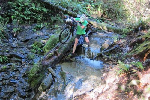
No easy stream crossings here
Just us and the mountains (Photo: Hamish Southcott)
An easy 20 km road ride in the early morning frost soon turned to a sharp incline on a Pylon track which soon had us shedding layers. For the first time in the journey we encountered a few navigational problems on the largely un-signposted route. Back on track after a slight detour that ended in practically a cliff, the four wheel drive route wound downwards and veered to the left when it met the border of Kahurangi National Park. Our route set us straight onto a narrow, muddy, rocky path that crossed countless un-ridable streams, steep switchbacks and slippery slopes. It was ‘fun’ after the well graded tracks the previous few days but flowing it was not! We were thankful of our relatively good progress to date as we clocked up the 16 km ascent / traverse in an agonisingly slow five hours. We laughed, we cried, we fell, but the scenery once again had the last laugh. Who couldn’t enjoy the stunning beach forests, raging water and Tui soundtrack, karst outcrops and the sheer adventure of it all? It was adventure we came for after all. Although the climbs and distances of the Ghost Rd. and the Heaphy had been challenging at time, the well-groomed tracks and huts definitely diminished the feeling of adventure at times. The Flora Saddle definitely added it back in to the trip…although we were both rather glad when it ended!
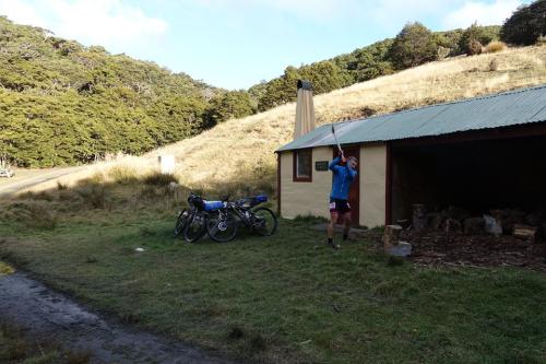
Finally time for some real work at Flora Hut (Photo: Hamish Southcott)
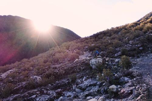
At the junction to the ominous sounding asbestos cottage – although it did sound warm, we snacked while once gain a South Island Robin hopped around our mud encrusted bikes and bodies. Weary of the day drawing in once again and having achieved very little in terms of mileage we began the final climb upwards. I heard a few Whio (Blue Duck) while crossing some tributaries and again outside our final resting place for the night.
Flora Hut is one the oldest remaining huts in the area and is rather strangely two huts separated by a wood shed. We both immediately set to manly activities – wood chopping while trying not to cut of the heads of the curious weka, bicycle maintenance and fire making. As the sun soon disappeared we got the large open fire roaring and took up position only marginally far enough away to prevent spontaneous combustion. Smelly socks dried (in my case to the point of burning holes in them) while food was cooked on the hot embers. After a well-earned feed, it was time for some sleep. It was a cold night in our summer sleeping bags, especially as nearly all the heat from the fire went straight up the chimney. However fully clothed, bedecked with balaclavas and thermal underwear, we slept reasonably well until our chilly start and day five awaited.
After a short climb in nearly all the clothing I had with me, we plummeted down so quickly, we undid the eight hours of climbing we had done the day before in less than 15 minutes…. such is the joy of cycling! Back in cow land one more time we started heading up valley once again for our second breakfast at Tapawera, and then navigated beautiful gravelled backcountry roads (despite the cows) to the shores of Lake Rotoroa.
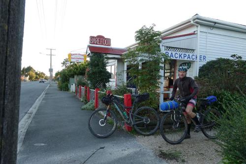
Me smelling the pies on the way into Murchison (Photo: Hamish Southcott)
It had been a smidgen over eight years since I had been to Lake Rotoroa where I had passed through during the inaugural Kiwi Brevet. We reminisced while we climbed up and over the beautiful Braeburn Rd which eventually spat us out of the main road about 5km before Murchison; our car awaiting for as we had left it five days earlier.
We were chuffed to complete our long planned three pass loop. All up, my ‘very rough’ estimate for distance travelled was 180 km on sealed roads, 150 km gravel bashing and a sweet 200 km of bush laden single track. Altitude gain I would guess about 5000 m all up. The five day time limit was perfect in the end, although bad weather and mechanicals may have put paid to that plan. However it didn’t with the weather definitely looking after us this time.
Murchison saw us taking on calories in the form of pies and then the long drive back to Christchurch sufficed as the rain slowly moved back in – I might add I found that part of the journey the most exhausting!
sifter
May 23, 2017 -
Great write up thanks Tim. Can’t wait to get in amongst some of this!!